Natural Hazards

The City is currently engaged in Natural Hazards planning to identify potential natural hazards to people and property within the boundaries of McMinnville's city limits and urban growth boundary, and then to identify ways to mitigate those hazards so that development can occur safely. This is a requirement of the Oregon Land Use System (Goal 7). The state, counties and cities are required to do this type of planning.
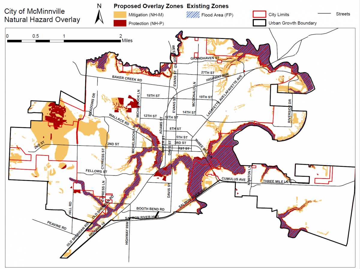
In McMinnville's program, we are focused on the following hazards: Wildfire, Landslides, Steep Slopes, Soil Conditions - Liquefaction and Shaking, and Floods (click the links to see the individual maps). New data has emerged in the past ten years that indicates that there are areas within McMinnville that are impacted by these hazards, and as a result after two years of study and consultant recommendations, two zones are being proposed to help development occur safely in these areas - 1) Natural Hazard Mitgation Zone; and 2) Natural Hazard Protection Zone.
Find your property on our interactive map. This map will show you if your property is impacted and by which zone it is impacted. Then review the proposed zones below to see what it means for your property. Call us if you have questions. We are here to help you understand the proposed program.
Proposed Zoning
- Natural Hazards Overlay Zone - Proposed code language for the Natural Hazard Mitigation Zone and the Natural Hazard Protection Zone. This chapter will indicate what you can and cannot do in these two zones.
- Flood Area Zone - This zone already exists and does not allow any development in the Flood Area. However there are some proposed amendments to the existing zone.
Upcoming Events - Learn More and Participate in the Dialogue
Planning Commission Public Hearings: The Planning Commission has started a public hearing on this program. It is anticipated that the public hearings will span over several months and meetings as the Planning Commission listens to public testimony and refines the progrram and recommendation to the City Council. The Planning Commission will be considering the following documents for recommendation to the City Council. It is anticipated that these will be amended and tweaked as the public hearings progress.
- 2021 Natural Hazards Inventory & Management Program Options and Recommendations Plan.
- Appendix 1: Best Natural Hazards Practices Memorandum
- Appendix 2: Natural Hazard Overlay Methodology
- Appendix 3: Revised Natural Hazard Inventory and Natural Hazard Overlay Maps
- McMinnville Comprehensive Plan Text Amendments (Chapter XI, Natural Features)
- McMinnville Municipal Code Text Amendments (Chapter 17.48,00 Flood Plain Area Zone and 17.49.00 – Natural Hazard Overlay Subdistricts)
- McMinnville Zone Map Amendments for Natural Hazard Mitigation and Protection Overlays (NH-M and NH-P)
All meetings will be conducted in a hybrid format with the ability to participate in person at the Kent Taylor Civic Hall, 200 NE Second Street or on zoom via the zoom meeting link. Please click on the planning commission meeting links below to learn more
- Planning Commission Public Hearing, April 6, 2023
- Planning Commission Public Hearing, May 4, 2023
- Planning Commission Public Hearing, June 15, 2023
- Planning Commission Public Hearing, July 20, 2023 (Please note that this hearing was continued to August 17, 2023)
- Planning Commission Public Hearing, August 17, 2023 (Please note that staff is requesting a continuance to October 19, 2023)
- Planning Commission Public Hearing, October 19, 2023 (Please note that staff is requesting a continuance to December 7, 2023)
- Planning Commission Public Hearing, January 4, 2024 (Please note that staff is requesting a continuance to March 7, 2024)
Past Events
Property Owner Public Information Session
When: Monday, March 20, 2023 at 4:00 PM
Monday, March 27, 2023 at 4:00 PM
Where: Hybrid - your choice of Virtual - via Zoom or In-Person - Community Development Center Large Conference Room (231 NE Fifth Street)
Public Information Session - Meeting Materials
- March 20 Meeting Presentation
- March 20 Meeting Video Passcode: E*idvH8t
Background
Goal 7 of the Oregon Land Use system requires cities to conduct natural hazard planning to protect people and property from the potential harms of natural hazards. The City started this planning effort in 2019 in partnership with Yamhill County as part of the Yamhill County Multi-Jurisdictional Hazard Mitigation Plan.
Proposed Vision
The proposal would adopt new standards for the mitigation of known natural hazards in all zoning districts by adopting the following:
- The 2021 Natural Hazards Inventory & Management Program Options and Recommendations Plan.
- Comprehensive Plan text amendments (Chapter X1, Natural Features)
- Zoning Ordinance text amendments (Chapter 17.49, Natural Hazard Overlay Subdistricts, and amendments to Chapter 17.48, Flood Plain Area Zone))
- Zoning Map Natural Hazard Mitigation and Protection Overlays
Important Documents:
- Oregon Natural Hazards Mitigation Plan
- Yamhill County Natural Hazards Mitigation Plan (Adopted 2019)
- McMinnville Natural Hazards Inventory and Management Program (proposed for adoption)
- Comprehensive Plan, New Chapter XI, Natural Features (proposed for adoption)
- Chapter 17.48, Flood Area Zone, McMinnville Municipal Code (proposed amendments)
- Chapter 17.49, Natural Hazards Overlays, McMinnville Municipal Code (proposed new chapter)
Meetings Archive
- Planning Commission Public Hearing, April 6, 2023
- Planning Commission Work Session, February 16, 2023
- Joint City Council and Planning Commission Work Session, June 28, 2022
For any further questions regarding Natural Hazards information, feel free to reach out to the Community Development Director, Heather Richards, directly at Heather.Richards@mcminnvilleoregon.gov

 Community Development Director: